Date: Sunday 16th August
Leader: Miles
Meet time: 09:15
Start time: 09:30
Estimated finish time: 15-15:30
Note: The end time, distance and ascent may be a little less or a little more than given. I have based these figures on a walk that covers Rowling End, Causey Pike, Scar Crags, Sail, Crag Hope, Wandope and Whiteless Pike. Wandope is optional though it is a minor addition and easily reached. While Grasmoor, which has not been included, is another possibility.
Distance: approx 7miles (11.2km)
Ascent: about 3015 ft (920m)
Ramblers walk grading (click here to find out what this means): Strenuous
Start point: The lay-by immediately next to the old landslip on Barrow’s eastern side (it will look like a great chunk taken out of the mountain).
What3Words: ///stitching.blackbird.gave
Please Register using the form at the bottom of the event page if you intend to join the walk.
Car parking: The lay-by immediately next to the old landslip on Barrow’s eastern side (it will look like a great chunk taken out of the mountain).
(Car sharing may be possible – please contact the walk leader to arrange)
It is the responsibility of each walker to make sure they understand where to park. If you are not sure where the car parking/meeting point is, you must contact the walk leader at the latest the day before the walk. You should not rely on mobile phones or postcodes. There is often no mobile reception near walk meeting points and postcodes are for the nearest place nearby but should only serve as a guideline. Please allow plenty of time to find a parking space so that walks can start promptly.
Summary
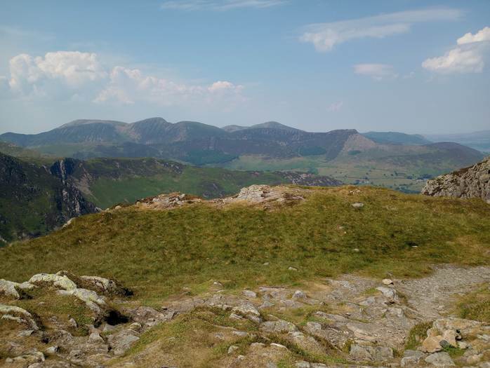
This is one of my favourite linear routes which starts from the mouth of the Newlands Valley, goes to Causey Pike, then Scar Crags, then Sail, then Crag Hill, then Whiteless Pike and finally the descent to Buttermere. This is a surprisingly easy ridge walk and, on a clear day, has some of the best views of the northwestern fells.
Description
We start by going along the Newlands Road for about a kilometer, the good news is that there is a grassy verge and the road is quite straight as we head for Stonycroft Gill. Once past the road bridge, and going over Stonycroft Gill, we are on the right side of the gill and will take a path that leads straight for Rowling End.
This is a steep winding ascent, of about 1000 feet, but the path is sturdy, though there are a few small scrambling sections as the path cuts through the heather, and eventually levels out to Rowling End (433 meters) which is the easternmost point of the ridgewalk.
From Rowling End we see pretty much most of the “ridge” walk ahead and most of the mountains this walk goes to. The highlights of Rowling End are the views of Cat Bells and the three Newland Valleys. Once at Rowling End, we go on a leisurely westwards stroll as Causey Pike grows ever closer and its knobble on top catches the eye.
Eventually we come to the second ascent of the walk, almost as steep as Rowling End but not as high, as we go up about 500 or so feet to get to the top of Causey Pike. Once we reach the base of the knobble, we find the path takes us to small craggy rock faces. This is doable but care must be taken in this scramble to reach the top.
Once at the knobble, the highest point of Causey Pike (637 meters), we see three other knobbles of almost similar height which is the magic of Causey Pike. While Causey Pike has more or less similar views of Rowling End, they are much higher, and the eye is drawn to the distant Crag Hill from where this ridge begins.
Now we began the ridge walk proper, though there is no ridge just a nice grassy / gravelly path that takes us to Scar Crags (672 meters) and then to the Coledale / Newlands pass. The only special thing about the pass is looking up the eastern slopes of Sail to see a wide gravely path doing a slalom up the mountain! This third ascent, of another 500 feet, is quite easy due to the s-bends that reduce the gradient.
Sail (773 meters) is unfortunately eclipsed by the nearby Crag Hill, but we will go the summit for all those who need to bag their Wainwrights, but it the actual ridge between Sail and Crag Hill that is one of the highlights of this walk. The Buttermere mountains, the western trio, can clearly be seen yet it is the perfect view downwards of Sail Beck which I find the most mesmerizing. This part of the “ridge” walk is an actual ridge but very tame, though care is needed if windy or if icy. The ascent to Crag Hill is the shortest of the ascents though there are a few mild scrambling sections.
Crag Hill is the 2nd highest mountain of the northwestern fells coming in at 839 meters. While Grasmoor is only 13 meters higher I have found that the best vantage point in this northwestern region is Crag Hill which amazes no matter where you turn- it even makes Grasmoor more attractive than it actually is!
This is where the magic of a linear walk really kicks in as we leave behind Newlands and enter into the Buttermere / Crummock Water area. We descend from Crag Hill to come a crossroad of paths and a few choices ahead of us. If pressed for time one could take the southern path which heads off to Whiteless Pike and Buttermere. Or we can a follow a grassy trod to reach Wandope (772 meters) which is very effortless and quick, or we could go to Grasmoor but by going there we only have to return to the crossroads once more.
What I usually do is head for Wandope since this is another great vantage point and easy one to go. From Wandope we see the last third of the walk. But just because we are descending does not mean an end to the views. We follow a different ridge, Whiteless Edge, to come to the final mountain of the walk: Whiteless Pike (660 meters).
This is one of my favourite ridgelines given the views of the Buttermere mountain trio and the Lad Hows ridge running off Grasmoor. After Whiteless Pike the descent hastens as it is about a mile and a half to Buttermere. There are a few scrambling sections on the top third of Whiteless Pike that are awkward though thankfully there are no drops. But careful footwork is required here.
Just as the walk is nearly finished there is one final surprise: the path goes through a section of woodland around Mill Beck and a few clearings reveal Haystacks and other distant mountains. By this point we are within ten minutes walking distance from Buttermere and close to cafés!
That’s the route but throughout there are all kinds of glorious views: the western side of Cat Bells, the ridge between Knott Rigg to Ard Crags, Grisedale Pike looming over to the north, the rocky line of Whiteside, seeing the Skiddaw massif from its roots to its peaks, and many other things little to large. All depending on the weather of course!
=================================
So how does this linear walk work for cars? Well most of us will gather at the designated start point. A few of us, myself included, will meet up at Buttermere by 9am. From this smaller group one person will drive us to the designated start point.
Once the walk is complete there will be 3 to 4 of us who can use our cars to shuttle the rest of the group back to the designated start point and to the lay-by where everyone else has parked up. Which means everyone will be in their cars. Now the drive from Buttermere to the lay-by is about 15 minutes.
I will ask a few people (who have told me they are joining this walk) if they can meet first at Buttermere by or before 9am.
Please check the weather and bring appropriate clothing (waterproofs and spare warm clothing), footwear and enough food and water. The leader reserves the right to turn away any walker not suitably equipped. The leader may cancel the walk or modify the route dependent on conditions.
New members
Check your walk suitability, we suggest starting with an Easy to Moderate walk. Unless the event is cancelled just turn up at the meeting point on time, and introduce yourself to the walk leader! Subscribe to our Facebook page and email list, or join our WhatsApp group to stay up-to-date!
Unsure what to pack? Check out our guide here: UK Hillwalking: Seasonal Equipment & Clothing Guide – SuMMit Good
Please note the walk leader may not be in contact prior to an event; however, they may ask for more information about your walking experience. This is to ensure you have the fitness required to complete the walk that is planned safely.
Attending? Please register your intent to join the walk using the booking form below before 6pm the eve of the walk.
Registration Form
One form entry per person please. Resubmit the form if registering additional persons.
You we strongly recommend carrying an ICE card. Available here:
If you have further questions regarding the walk you can contact the leader via the form below.