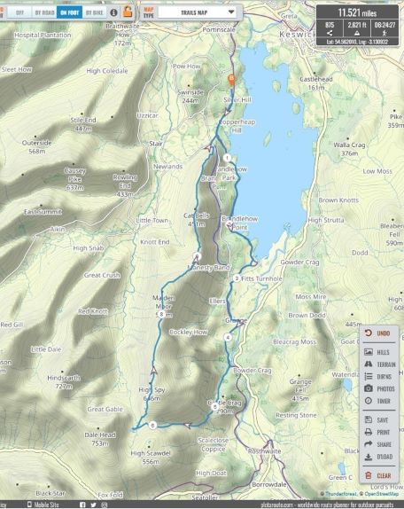
Meet time: 8.45am
Start time: 9am
Estimated finish time: 4pm
Distance: 11.5 to 11.6 miles (18.51 – 18.67 kilometres)
Ascent: About 2620 feet (797 meters)
Ramblers walk grading: A (Strenuous)
Start point: Car park for Lingholm Estate
Postcode: CA12 5TZ (The Lingholm Kitchen)
Car parking: There is a car park just west of Lingholm Estate where the Cumbria Way goes through it. This car park is about a mile south of Portinscale (accessed via A66). Outside of Portinscale on the Grange / Newlands road there is a small country lane forking rightwards which is signposted to Braithwaite, stick to the Grange / Newlands road as shortly afterwards there is turnoff to the left which is signposted with “The Lingholm Kitchen”. Follow the lane and it come to the car park.
It is the responsibility of each walker to make sure they understand where to park. If you are not sure where the car parking/meeting point is, you must contact the walk leader at the latest the day before the walk. You should not rely on mobile phones or postcodes. There is often no mobile reception near walk meeting points and postcodes are for the nearest place nearby but should only serve as a guideline. Please allow plenty of time to find a parking space so that walks can start promptly.
Description: The walk starts from Lingholm car park and follows the Cumbria Way going down the forested western shore of Derwent Water to reach Grange. Continuing southwards the paths go through woodland before ascending up Broadslack Gill which goes up the western slopes of Castle Crag (and eastern slopes of High Spy). The path continues hugging the lower slopes of High Spy before bending westwards and going up Tongue Gill.
After ascending about a thousand feet the path peters out and flattens out, it comes to wide hollow and there in the centre is Dale Head Tarn. There are various bits of shelter by crags next to the mouth of Dale Head Tarn which is perfect for a lunch break.
Following lunch there is an ascent of about five hundred feet which gradually meanders upwards to High Spy, the highest mountain of the walk at 653 meters. If there’s no mist then the views will be incredible as High Spy is considered to be part of the centre of the Lake District: to the north is the distant Skiddaw Range, to the east are various valleys and the Helvellyn Range, to the south can be seen some of the Langdales and part of the Scafell Range, and to the east is the very steep Newlands Valley.
From here the walk is a relaxing and very gradual descent northwards as the path comes to first Maiden Moor and finally Cat Bells- the final high point. After Cat Bells there is one final descent (a bit steep) until the route takes up the Cumbria Way once more to return to Lingholm.
Please contact Miles on 07842 783319 by 10pm on Friday 4 November if you are coming on this walk (text or phone, or message on Facebook (Miles Saunders-Priem)). This walk is suitable for dogs but please make sure you keep your dog under control.
Please check the weather and bring appropriate clothing (waterproofs and spare warm clothing), footwear and enough food and water. The leader reserves the right to turn away any walker not suitably equipped. The leader may cancel the walk or modify the route dependent on conditions.
Car sharing is now possible – please contact the walk leader to arrange.
New members: please note the walk leader may ask for more information about your walking experience. This is to ensure you have the fitness required to complete the walk that is planned safely.