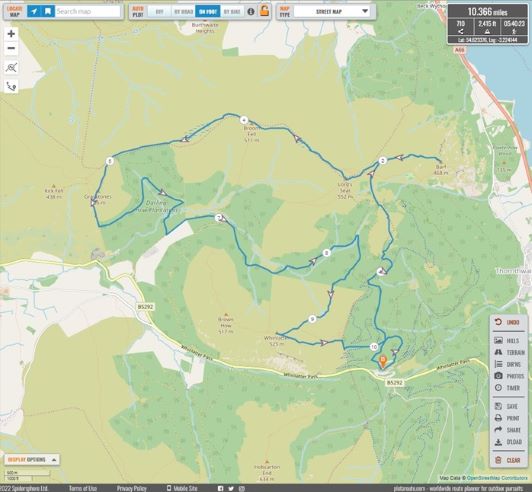
Walk title: Northern Whinlatter Horseshoe
Group: Summit Good
Meet time: 9.15am
Start time: 9.30am
Estimated finish time: 3.30pm
Distance: 10.3 to 10.4 miles (16.58 – 16.74 kilometres)
Ascent: About 2,415 feet (736 meters)
Ramblers walk grading: B+ (Moderate)
Start point: Whinlatter Visitor Centre
Postcode: CA12 5TW
Car parking: There is a car park surrounding the Whinlatter Visitor Centre, along the Whinlatter Pass close to the Visitor Centre there are various lay-bys along the way where there is free parking.
It is the responsibility of each walker to make sure they understand where to park. If you are not sure where the car parking/meeting point is, you must contact the walk leader at the latest the day before the walk. You should not rely on mobile phones or postcodes. There is often no mobile reception near walk meeting points and postcodes are for the nearest place nearby but should only serve as a guideline. Please allow plenty of time to find a parking space so that walks can start promptly.
Description: This is a walk for those new to hiking or for those returning to it or for those who want a gentle stroll. It starts at the Whinlatter Visitor Centre which is about 300 meters (roughly a 1,000 feet) so most of the climb is already done. We take a wide gentle forest trail and head northwards into the forest. Taking a smaller path, we come to the first mountain which is Ullister Hill, which is a mound-like rise covered in heather but with views of both southern Whinlatter and the walk’s highest mountain: Lord’s Seat.
From here the trees thin out and we are greeted by heather and moorland, avoiding Lord’s Seat the paths veer gradually eastwards to the first Wainwright of the walk: Barf, and this mountain has spectacular views of Bassenthwaite Lake and the Skiddaw Range. We then head westwards and gently ascend to Lord’s Seat which at 552 meters (1811 feet) is the highest point of the walk and the second Wainwright. From here the walk becomes a comfortable stroll westwards as two further Wainwrights are bagged: Broom Fell and Graystones.
After Graystones we move downwards and eastwards into the Darling How Plantation, we lost some height when the path reaches Aiken Beck as we take the longer and more scenic route to the final Wainwright. As the forest trail ascends upwards we go in the direction of Ullister Hill, but before we get there the forest trail goes southwards and back into the heart of Whinlatter Forest.
Along this forest trail we will eventually take the easy-to-miss biker’s trail to begin the approach to Whinlatter Top. On the biker’s trail we take a very subtle path which is little more than a gentle groove no bigger than a person’s foot to approach Tarbarrel Moss. This is necessary to reach the stile, and this will save us having to go over the fence. Once at Tarbarrel Moss it’s an easy walk to Whinlatter Top across open moorland.
Upon Whinlatter Top (fifth Wainwright) there are glorious views all around, especially southwards towards Grisedale Pike. With the last mountain done it’s a quick and direct route back to the Whinlatter Visitor Centre.
So that’s five Wainwrights completed with relative ease!
Please contact Miles on 07842 783319 by 10pm on Friday 2 December if you are coming on this walk (text or phone, or message on Facebook (Miles Saunders-Priem)). This walk is suitable for dogs but please make sure you keep your dog under control.
Please check the weather and bring appropriate clothing (waterproofs and spare warm clothing), footwear and enough food and water. The leader reserves the right to turn away any walker not suitably equipped. The leader may cancel the walk or modify the route dependent on conditions.
Car sharing is now possible – please contact the walk leader to arrange.
New members: please note the walk leader may ask for more information about your walking experience. This is to ensure you have the fitness required to complete the walk that is planned safely.