Meet time: 9.15am
Start time: 9.30am
Estimated finish time: 1.30pm to 2.30pm
Distance: 5.9 miles (9.5 kilometres)
Ascent: About 2,360 feet (719 meters)
Ramblers walk grading: A (Strenuous)
Start point: Lay-by / car park by Cross Keys Temperance Inn (on the A683 road).
Postcode: LA10 5NE
Car parking: There is a lay-by, on both sides of the A683 road, right next to the Cross Keys Temperance Inn. Further up the road (eastbound) there are several smaller lay-bys within half a mile of the start point.
It is the responsibility of each walker to make sure they understand where to park. If you are not sure where the car parking/meeting point is, you must contact the walk leader at the latest the day before the walk. You should not rely on mobile phones or postcodes. There is often no mobile reception near walk meeting points and postcodes are for the nearest place nearby but should only serve as a guideline. Please allow plenty of time to find a parking space so that walks can start promptly.
Description: The Howgills are a series of mountains, tongues and valleys which are almost as good as the Lake District. The Howgills are between the Lake District and the Pennines. But this is a very quiet, obscure area.
This walk goes to some of the best features of the Howgills: Cautley Spout, The Calf and Yarlside. If you’ve never heard of the Howgills or never walked them, here is a chance to walk upon mountains very different from the Lake District and the Pennines.
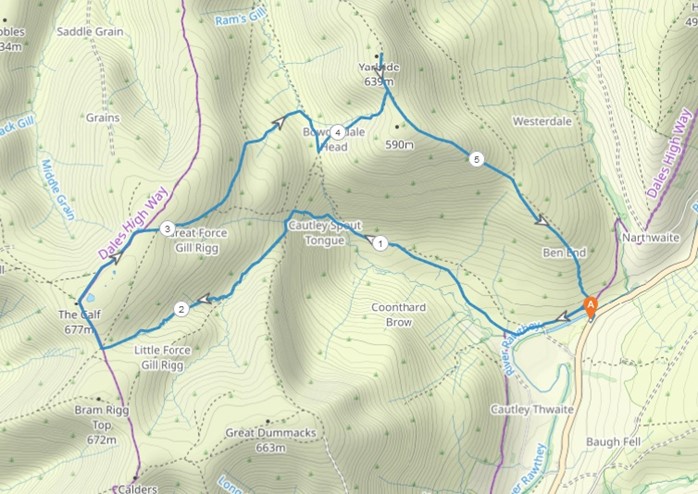
This walk starts from the lay-by next to the Cross Keys Temperance Inn and immediately crosses the Rawthey River via the footbridge, it then goes around a few drumlins until the valley containing Cautley Spout fully reveals itself. This is perhaps the one area of the Howgills that most resembles the Lake District with distant crag faces to the left and the steep slopes of Yarlside to the right. The path gently dips up and down as it approaches Cautley Spout; all the while the mountains loom over us.
Once the slope steepens, we will be very close to Cautley Spout and there we ascend about 600 to 700 feet, along the way the several waterfalls which comprise Cautley Spout gradually reveal themselves. The steep path abruptly veers left and flattens out. After a smaller ascent the path at last reaches the very small and narrow valley that is Force Gill Beck. If the weather is misty or if the cloud has set in, then we follow the path that goes straight to The Calf.
However, if there are views, we could take a bit of detour by following a desire line which follows the ridgeline of Cautley Crag- this is a grassy route but to our left will be sweeping views of the valley we originally walked through. This alternate route reaches a small grassy plateau called Great Dummacks, from there we take a path to reach Calders (The Cow)- this is 674 meters high and is the second highest mountain of the Howgills. But the views are vast, especially towards the far-off sea and of course the Lake District! From Calders we follow a track which goes straight to The Calf, and this track marks most of the highest points of the Howgills.
If we ignore Calders and go straight to The Calf, then we will save about thirty minutes of walking, and come to the highest point of the Howgills. The Calf is 676 meters high and it has the best views of the Eden Valley and the Pennines- while most of the Lake District can be seen as well.
From The Calf we take the path that goes to Bowderdale, this is one of the Howgills long valleys separated by tongues (grassy mountain “ridges”). We shall briefly leave the path to walk on the tufty grass to make a beeline to Bowderdale Head. This is 431 meters high and has views of Cautley Spout. It’s nestled between Cautley Spout, Yarlside and the Bowderdale/Langdale tongue and reveals one of the unique features of the Howgills- the valleys between its numerous tongues.
It will be from Bowderdale Head that the final stage of the walk shall begin. There is a faint path that follows a shallow gill that cuts into Yarlside somewhat. Now Yarlside is the last mountain of this walk, but it is a mountain of two peaks of similar height. The gill ends between the two peaks. The path does peter out, but the direction is clear as we walk up the grass to reach the path that runs through the two peaks of Yarlside. The final ascent is to reach the highest point of Yarlside which is 639 meters. This is a prominent mountain in the eastern part of the Howgills and offers generous views of the Pennines and also reveals large sections of limestone pavement that are upon the slopes of Wild Boar Fell.
Finally, we begin a descent in a south-easterly direction down the long slopes of Yarlside to return to the footbridge of Rawthey River- the start point of the walk.
OPTIONAl: If it remains cloudy when we reach Bowderdale Head and there are no views from the mountain tops, then we do have the option of taking a path that enters the valley containing Cautley Spout, this runs about halfway up the southern slopes of Yarlside. This would make the walk a bit shorter- but I leave this to the group to decide.
Please contact Miles on 07842 783319 by 10pm on Friday 25 August if you are coming on this walk (text or phone, or message on Facebook (Miles Saunders-Priem)). This walk is suitable for dogs though there are small groups of sheep dotted all around the Howgills- in my recce I noticed that quite a few of these sheep are quite standoffish and tend to stand their ground!
Please check the weather and bring appropriate clothing (waterproofs and spare warm clothing), footwear and enough food and water. The leader reserves the right to turn away any walker not suitably equipped. The leader may cancel the walk or modify the route dependent on conditions.
Car sharing is now possible – please contact the walk leader to arrange.
New members: please note the walk leader may ask for more information about your walking experience. This is to ensure you have the fitness required to complete the walk that is planned safely.