Meet time: 9.15am
Start time: 9.30am
Estimated finish time: 4.30pm to 5pm
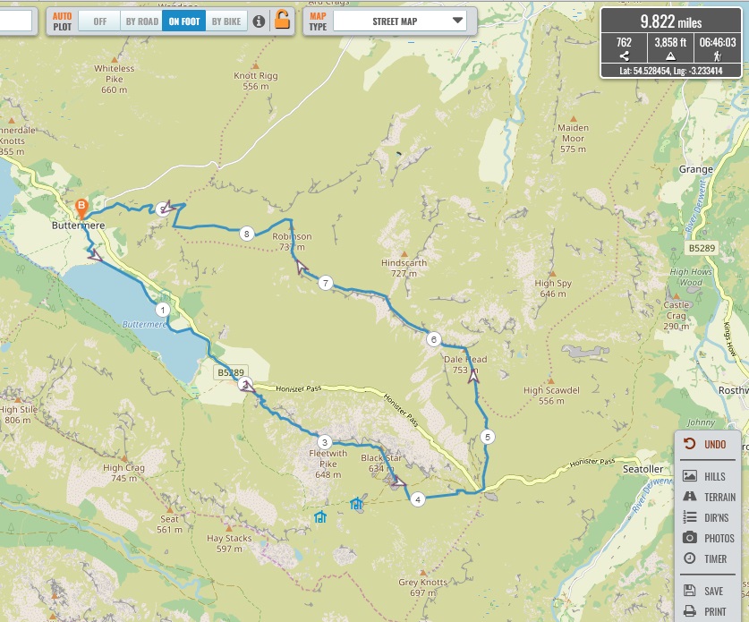
Distance: 9.8 to 9.9 miles (15.77 – 15.93 kilometres)
Ascent: About 3,860 feet (1,177 meters)
Ramblers walk grading: A (Strenuous)
Start point: Syke Farm Tea Room
Postcode: CA13 9XA
Car parking: There is a car park immediately west of The Buttermere Court Hotel, there is also free parking on the side of the Newlands Pass road- immediately east of Buttermere Village.
It is the responsibility of each walker to make sure they understand where to park. If you are not sure where the car parking/meeting point is, you must contact the walk leader at the latest the day before the walk. You should not rely on mobile phones or postcodes. There is often no mobile reception near walk meeting points and postcodes are for the nearest place nearby but should only serve as a guideline. Please allow plenty of time to find a parking space so that walks can start promptly.
Description: This walk begins from Syke Farm Tea Room and takes a path going along the eastern shore of Buttermere Lake. After a pleasant southwards stroll along the shoreline there is a brief stretch where the route goes on the road until it comes to Gatesgarth Farm, from there the ascent begins proper by taking the steep path up Fleetwith Edge to reach the top of Fleetwith Pike, an ascent of about two thousand feet. There are amazing views of Haystacks, Buttermere, Great Gable and many other mountains all around.
Next the path continues along the long top of Fleetwith Pike until it comes to disused slate quarries, to save time the route will make a beeline for the tramway path which goes directly to the top of HonisterPass. Having descended by about a thousand feet we would come to a café for lunch.
After lunch it is a long ascent northwards towards Dale Head, the highest mountain of the walk coming in at 2470 feet. From the top of Dale Head are amazing views of Honister Pass, Fleetwith Pike and the many valleys of Newlands Valley. The route then becomes a leisurely stroll along first Hindscarth Edge and Littledale Edge, as an option Hindscarth could be quickly bagged along the way.
On the approach to Robinson there is one final ascent, a mere five hundred feet, to get to the top and to the second highest mountain of the walk. There are incredible views of Buttermere, Grasmoor, Crag Hill, Newlands Valley, Skiddaw Range and much more!
A great descent begins from Robinson and it comes down to a somewhat boggy plateau called Buttermere Moss, crossing it we come to the last mountain of the walk: High Snockrigg, the mountain which looms over Buttermere Village. High Snockrigg has great views of the western Buttermere mountains and at last Buttermere Village can be seen. After taking a steep, winding path down the walk is complete when we come back to Buttermere Village and Sykes Farm Tea Room.
Social in the Evening: In Keswick there is the option of joining us for dinner at Stonehouse Pizza restaurant from 8.30pm. For more details, please see here.
Please contact Miles on 07842 783319 by 10pm on Friday 19 August if you are coming on this walk (text or phone, or message on Facebook (Miles Saunders-Priem)). This walk is suitable for dogs and few sheep are found on the mountains between Honister Pass and High Snockrigg.
Please check the weather and bring appropriate clothing (waterproofs and spare warm clothing), footwear and enough food and water. The leader reserves the right to turn away any walker not suitably equipped. The leader may cancel the walk or modify the route dependent on conditions.
Car sharing is now possible – please contact the walk leader to arrange.
New members: please note the walk leader may ask for more information about your walking experience. This is to ensure you have the fitness required to complete the walk that is planned safely.